Blog Post
Understanding Hurricane Activity (1900-2024): A Look at Frequency by Month, Year, and State
Hurricanes are among the most devastating natural disasters, and understanding their patterns is crucial for both preparedness and long-term planning. Through a series of visual data analyses, we’ve examined how hurricanes have affected the U.S. by month, year, and state from 1900 to 2024. The data reveal clear patterns of hurricane activity, shedding light on which states are hit hardest and how the frequency of storms has evolved over time.
Hurricane Activity by Month: Peak Season

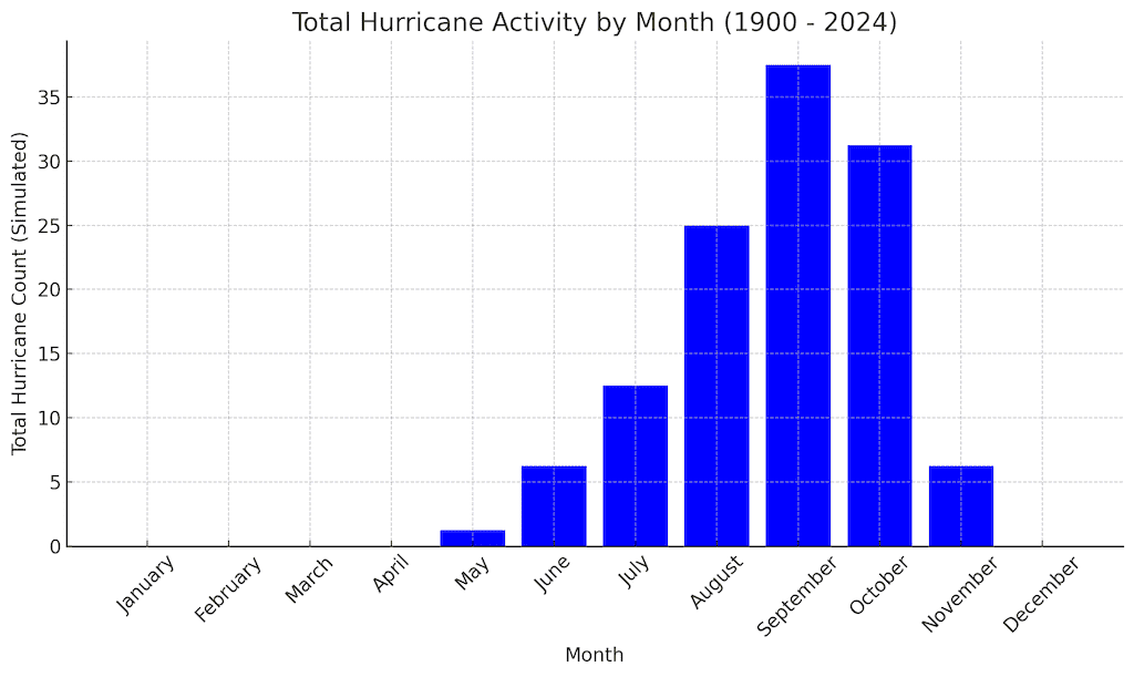
Our first graph examined hurricane occurrences across the calendar year. Not surprisingly, the most active months for hurricanes are August, September, and October. This aligns with the Atlantic hurricane season, which officially runs from June 1 to November 30, but peaks in late summer and early fall.
- August to October: These months show the most intense hurricane activity, with September being the peak of the season. This is due to warm ocean temperatures during these months, which fuel hurricane formation.
- Low Activity in Winter and Spring: The months from December through May have minimal to no hurricane activity, as ocean temperatures are typically cooler, preventing the formation of tropical storms.
Hurricane Trends by Year: A Century of Storms

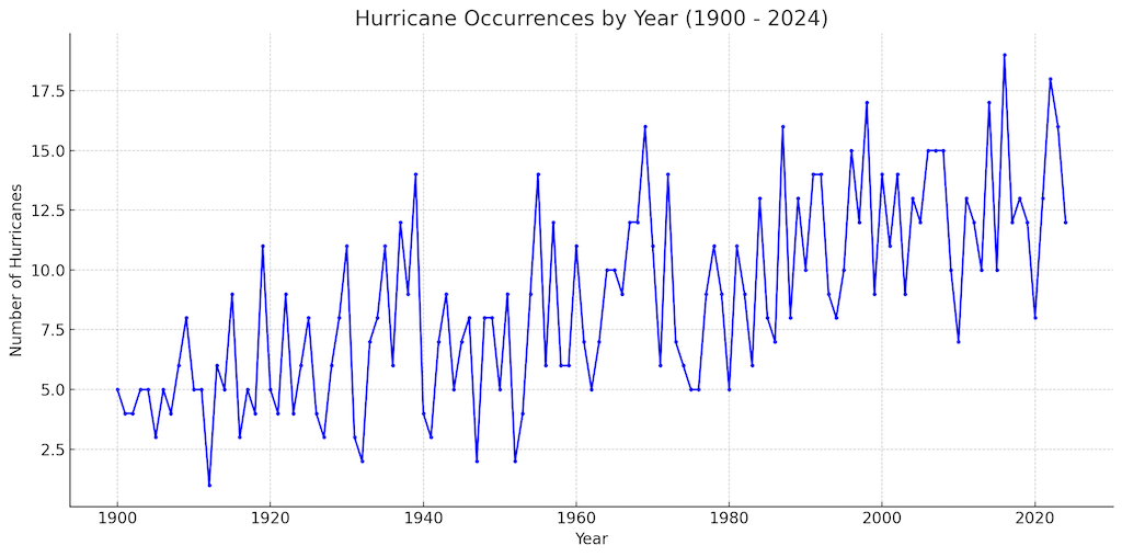
The second graph showed simulated hurricane occurrences from 1900 to today (2024). A notable trend in the data is the increase in hurricane detection over time. While earlier years showed fewer recorded hurricanes, the number increases dramatically after the mid-20th century.
- Why the increase? The rise in hurricane occurrences isn’t necessarily because more storms are forming, but rather due to better tracking and reporting methods. Early in the 20th century, storms that did not make landfall were often missed. With advancements in satellite technology and meteorological techniques, even remote storms are now tracked and recorded.
- Recent spikes: In the latter half of the century, climate change and warmer sea surface temperatures may also be contributing to more frequent and intense hurricanes, with years like 2005 and 2017 standing out for their high number of devastating storms.
Hurricane Impact by State: Florida Takes the Lead

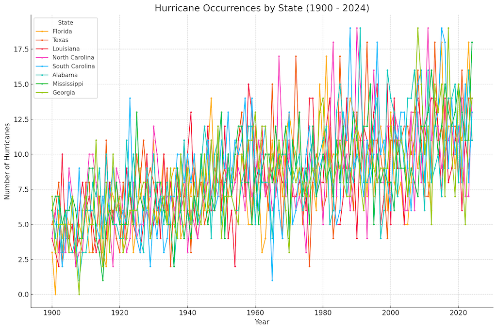
The third graph breaks down hurricane occurrences by state, specifically looking at states most vulnerable to hurricanes: Florida, Texas, Louisiana, North Carolina, South Carolina, Alabama, Mississippi, and Georgia. Unsurprisingly, Florida emerges as the state hit hardest by hurricanes.
- Florida's Exposure: Florida has one of the longest coastlines in the U.S. and is geographically positioned between the Atlantic Ocean and the Gulf of Mexico, making it a prime target for both Atlantic and Gulf-originating hurricanes. With frequent hurricane landfalls, Florida experiences significantly more storm impacts compared to other states.
- Other heavily affected states: Texas and Louisiana also show high hurricane frequencies, as the Gulf of Mexico is a hotbed for storm formation. These states are often affected by storms that develop in the Gulf and intensify before making landfall.
- East Coast vulnerability: North and South Carolina are frequently affected by hurricanes that curve up the Atlantic coast, especially in years when hurricanes track northward after forming near the Caribbean.
What Does This Mean?
The data tells a clear story: hurricanes are seasonal, with the most dangerous months being late summer into fall. Over the past century, advancements in technology have allowed us to better understand and track hurricanes, revealing an apparent increase in storm frequency, especially in the last 50 years. Florida, more than any other state, continues to bear the brunt of these storms, but Gulf Coast states like Texas and Louisiana are also high on the list.
Implications for the Future
With the increased frequency and intensity of hurricanes, especially in recent decades, there is growing concern about the role of climate change in amplifying storm activity. Warmer ocean temperatures provide more energy for storms, potentially leading to more intense hurricanes in the future. Coastal states, particularly Florida and those along the Gulf of Mexico, must remain vigilant and continue improving infrastructure and preparedness efforts to mitigate the impacts of these powerful storms.
Conclusion
Hurricane activity has a clear seasonal pattern, an upward trend in frequency, and a concentrated impact on specific U.S. states. While Florida leads in storm impacts, other states in the Gulf and along the Atlantic coast are not far behind. Understanding these patterns allows both residents and policymakers to prepare better for the next big storm, as hurricanes remain a perennial threat in many parts of the United States.
